SIRGAS

Loading

SIRGAS

Archives 2021

New technical guides of SIRGAS Working Group I

Within the framework of the objectives that SIRGAS carries out through its Working Group I to contribute to the development of regional geodesy, three new technical guides are made available to users on the activities carried out by the Working Group for the Determination of the Geocentric Reference Frame, according to IAG, IGS and IERS standards.

The first document developed by Working Group I is called “Guidelines for the coordination of the SIRGAS network” and describes the functional organization chart of the SIRGAS Working Group I and the SIRGAS-CON network, establishing the responsibilities and commitments of all the organizations and professionals involved.

The second document is entitled “Guidelines for the installation, operation and registration of SIRGAS-CON stations” and describes the guidelines, recommendations and commitments to install, operate and register a station in the SIRGAS-CON geodetic network.

The last document is called “Guidelines for SIRGAS-CON analysis centers” and presents the standards, guidelines and recommendations for processing SIRGAS-CON stations that any SIRGAS Analysis Center must apply.

The three documents were developed in Spanish and English, and can be downloaded from the SIRGAS website: https://sirgas.ipgh.org/en/resources/guidelines/

Technical Seminar on Reference Frames in Practice: Progress and Challenges in the Americas Region

Introduction

The International Federation of Surveyors (FIG) is the premier international organization representing the interests of surveyors worldwide. It is a federation of the national member associations and covers the whole range of professional fields within the global surveying, geomatics, geodesy and geo-information community. It provides an international forum for discussion and development aiming to promote professional practice and standards.

SIRGAS is the Geodetic Reference System for the Americas. Its definition corresponds to the International Terrestrial Reference System (ITRS) and it is realized by a regional densification of the International Terrestrial Reference Frame (ITRF) in the Americas. Besides the geometrical reference system, SIRGAS includes the definition and realization of a vertical reference system, based on ellipsoidal heights as geometrical component and geopotential numbers (referred to a global conventional W0 value) as physical component.

The RFIP Seminars are intended as a means to educate surveyors and other affiliated professions regarding the definition, maintenance and access to geometric and vertical reference frames, and their use and applications of GNSS for access. Additionally, appropriate standards, technology and tools are covered all as a part of education, training and capacity development.

Objective

While abbreviated in format, this seminar is intended to provide an overview of these topics in a virtual setting. To strengthen the advocacy and deliberation skills for geospatial experts and surveying professionals to effectively represent and communicate their positions and requirements to SIRGAS as a scientific body, the FIG as a professional organization and other professional fora. The focus will be on the surveying/geodetic/mapping needs from perspective of surveyor/practioner

Target Audience

Surveyors, GIS professionals, and other technical and professional representatives of Americas region.

Format

This side event will be hosted via the GoToWebinar platform on December 2 2021 between 18:00 and 20:00 UTC. It will comprise a series of presentations, a breakout groups exercise, panel discussion session, open discussion and closing remarks. The event will be conducted in English with Spanish translation on an ad hoc basis.

Registration URL https://attendee.gotowebinar.com/register/8207982263965818379

Webinar ID 771-993-987

Convenors

FIG Commission 5:

  • Dr. Daniel Roman (Chair)
  • Dr. Kevin Ahlgren (Vice-Chair-Administration)
  • Mr. David Avalos (Vice-Chair Vertical Reference Frames)

SIRGAS:

  • Dr. Demian Gomez (President WG II)
  • Dr. Dana Caccamise (U.S. rep. To WG II)

Times (UTC)

Discussion Area

Presenters

18:00-18:05
Welcome and Opening Remarks
Dr. Daniel Roman
18:05-18:20
FIG Overview
Dr. Daniel Roman

Mr. David Avalos

18:20-18:30
SIRGAS Overview
Dr. Demian Gomez
18:30-18:40
Bolivia: National Perspective
Dr. Arturo Echelar
18:40-18:50
Canada: Canadian Institute of Geomatics
Dr. Mir Abolfazl Mostafavi
18:50-19:00
French Guiana: Ordre des Géomètres-Experts
M. Paul Chambon
19:00-19:10
Jamaica: Land Surveyors Association of Jamaica
Mr. Christopher Grant
19:10-19:20
Trinidad and Tobago: Institute of Surveyors of Trinidad and Tobago
Dr. Dexter Davis
19:20-19:40
Discussion
All Participants
19:40-19:50
Future Seminars
Dr. Daniel Roman
19:50-20:00
Closing Remarks
Dr. Demian Gomez

Dr. Daniel Roman


2021 SIRGAS Symposium

A new edition of the SIRGAS Symposium will take place from November 29 to December 1, 2021. The main goal of the 2021 SIRGAS Symposium is to convene the geodetic community of the Americas and the Caribbean to exchange experiences and progress, as well as discuss new projects related to the implementation, maintenance, and use of the geodetic reference infrastructure in the region.

Due to the CoVID-19 pandemic, the 2021 SIRGAS Symposium will be held virtually through the Zoom platform. The event will be free of charge with English and Spanish simultaneous translation.

Although the SIRGAS Symposiums are mainly attended by National Representatives, members of the Working Groups and projects, these events are open to the entire international geodetic community, and therefore we cordially invite:

  • Representatives of regional organizations involved in the publication of geospatial information and Earth observations;
  • Representatives of national institutions responsible for the definition of geodetic reference frames;
  • Representatives of public and private agencies that use geodetic and geophysical information;
  • Representatives of universities and research centers on topics related to geodesy and geophysics; and
  • Scientists, professionals, technicians and students whose activities and research are related to SIRGAS.

The activities of the SIRGAS 2021 Symposium will be carried out in 5 sessions:

  • November 29 – Report of the SIRGAS authorities: President of SIRGAS, Presidents of the SIRGAS Working Groups and update of the GRFA of UN-GGIM: Americas;
  • November 29 – Development and maintenance of the SIRGAS reference frame;
  • November 30 – Modeling of the Earth’s gravity field (geoid, gravimetry, international reference system of heights);
  • November 30 – Applications of the SIRGAS reference frame (national reports, real-time applications, etc.); Y
  • December 1 – SIRGAS contributions to the modeling of the Earth System (troposphere, ionosphere, seismology, oceanography and hydrography).

There are two presentation types:

  • Oral presentations with a total presentation time of 15 minutes; and
  • Posters: available for download in PDF format, and will be presented orally in 5 minutes.

The 2021 SIRGAS Symposium is being organized by the Local Organizing Committee, composed by the Executive Committee of SIRGAS and representatives of the National Geographic Institute of Peru.  For any questions about the venue please contact sirgas2021@ign.gob.pe. This event has the support of the International Association of Geodesy and the Pan American Institute of Geography and History. For more details, visit the event website https://app.ign.gob.pe/simposio/

Finally, we would like to announce that the Journal of Geodetic Science (JoGS) is developing a special issue related to the 2021 SIRGAS Symposium, and therefore we invite front-line researchers and technological community to submit original research and review articles focused on Geodesy and Earth Sciences for its inclusion in this special issue of the journal. All manuscripts (research and review papers) should be submitted online at https://www.degruyter.com/journal/key/jogs/html. For more information download the call for papers.

New Experimental Processing Center SIRGAS in Costa Rica

The National Geographic Institute of Costa Rica (IGN-CR) begins activities as an Experimental Processing Center SIRGAS from GPS week 2170 (August 8, 2021). The main characteristics of this new Experimental Center are:

Name: National Geographic Institute of Costa Rica
Abbreviation: CRI
Processed stations: AACR ALEC AMCR BEJA BNGA BOAV BOGT BQLA CANO CIQE CJ01 CN19 COEC CRLP CRO1 DARI DPEC ECEC EPEC GLPS GUAT HC03 HV01 ICEP IDGO INEG LIBE LIMN LJEC LMMF LR01 MANA MERI MOTE MTY2 NAS0 NEIL NYCO PMEC POPA POVE PREC PUNT RIDC RIOP SAGE SCUB SNSN TAMP TEG2 TPEC TUNA UC01 UCRI VERA VIL2 VIVI ZARZ
Software: Bernese GNSS Software V. 5.2

With this new experimental processing center, SIRGAS is approaching the goal of having a scientific GNSS data processing center in each country in the region. SIRGAS thanks IGN-Pe for this initiative and for its continued support in all activities related to the establishment, maintenance, and development of the reference framework for the Americas.

New technical guides on the International Heights Reference Frame

Due to the objectives that SIRGAS carries out through its Working Group III to contribute to the development of regional geodesy, two technical guides on the International Heights Reference Frame (IHRF) have been published.

The first document developed by the Working Group III is called “Guidelines for IHRF station selection” and describes requirements and recommendations for the selection and implementation of an IHRF station. The guide is aimed at institutions that already have a station planned in the calculation of the first IHRF implementation, and at agencies that wish to propose new stations to integrate into the IHRF.

The second document is entitled “Guidelines for performing gravimetric measurements around IHRF stations” and describes the relevant requirements and recommendations for making land gravimetric measurements around IHRF stations through the use of relative gravimeters.

Both documents were developed in Spanish, Portuguese and English, and can be downloaded from the SIRGAS website: https://sirgas.ipgh.org/recursos/guias/

New SIRGAS web site: https://sirgas.ipgh.org/

In October 2002, the SIRGAS Directing Council decided the implementation of a web page summarising the main characteristics of SIRGAS. The design, maintenance and update of the SIRGAS web page was defined as a responsibility of the SIRGAS President and Vice-president. The first version of the SIRGAS web page was hosted by the Instituto Brasileiro de Geografia e Estatística (IBGE), affiliation of the SIRGAS President at that time, Luiz Paulo Souto Fortes. This web site described the objectives and structure of SIRGAS, included the new SIRGAS Bylaws, and contained the main SIRGAS products: SIRGAS95 and SIRGAS2000 coordinates and the first VEMOS model. Through this web site the routinely issue of the SIRGAS Newsletters was established. In December 2004, the SIRGAS Vice-president for the term 2003 – 2007, Eduardo Lauría, assumed the maintenance and modernisation of the SIRGAS web site and moved the wen from IBGE to the Instituto Geográfico Nacional (IGN) of Argentina. This new site offered interactive tools to easily find the SIRGAS95 and SIRGAS2000 coordinates for desired stations as well as to get station velocities from the VEMOS model. New sections corresponding to the SIRGAS Working Groups were introduced. In August 2007, the responsibility of the SIRGAS web maintenance is assumed by the new SIRGAS Vice-president, Laura Sánchez (term 2007 – 2015), and with the support of the Deutsches Geodätisches Forschungsinstitut, Technische Universität München (DGFI-TUM), the web is moved to www.sirgas.org. This new site initially kept the same design introduced by the IGN-Argentina and IBGE in the previous web sites, but the structure of the web is modified in accordance with the development of SIRGAS. New sections are implemented following the establishment of new SIRGAS components, in particular, the continuously operating reference network, the SIRGAS analysis centres of the reference network, the atmospheric analysis centres, and the SIRGAS products (weekly station positions, multi-year solution, deformation models VEMOS). An important component of the www.sirgas.org is the repository of a huge index of publications and presentations published by the SIRGAS community. In accordance with the recent developments in SIRGAS, specially the interaction with the Regional Committee of the United Nations on Global Geospatial Information Management for the Americas (UN-GGIM: Americas), it was decided to move the SIRGAS web page from www.sirgas.org to https://sirgas.ipgh.org/. The new site is hosted by the Pan-American Institute for Geography and History (PAIGH). Its maintenance continues being a responsibility of the SIRGAS President and Vice-president with the support of PAIGH. https://sirgas.ipgh.org/ contains basically the same information and data like www.sirgas.org, so that the SIRGAS users can assumed this transition smoothly. https://sirgas.ipgh.org/ is operative since August 2021.

Event: Geodetic Activities in the Americas

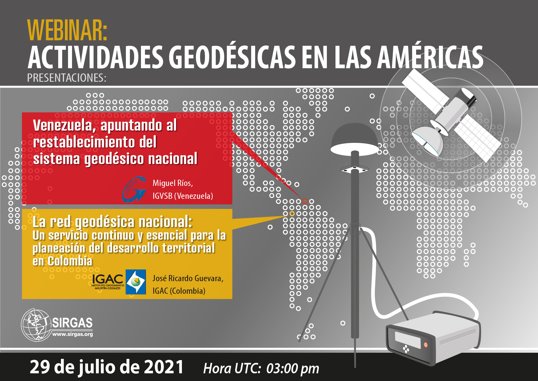
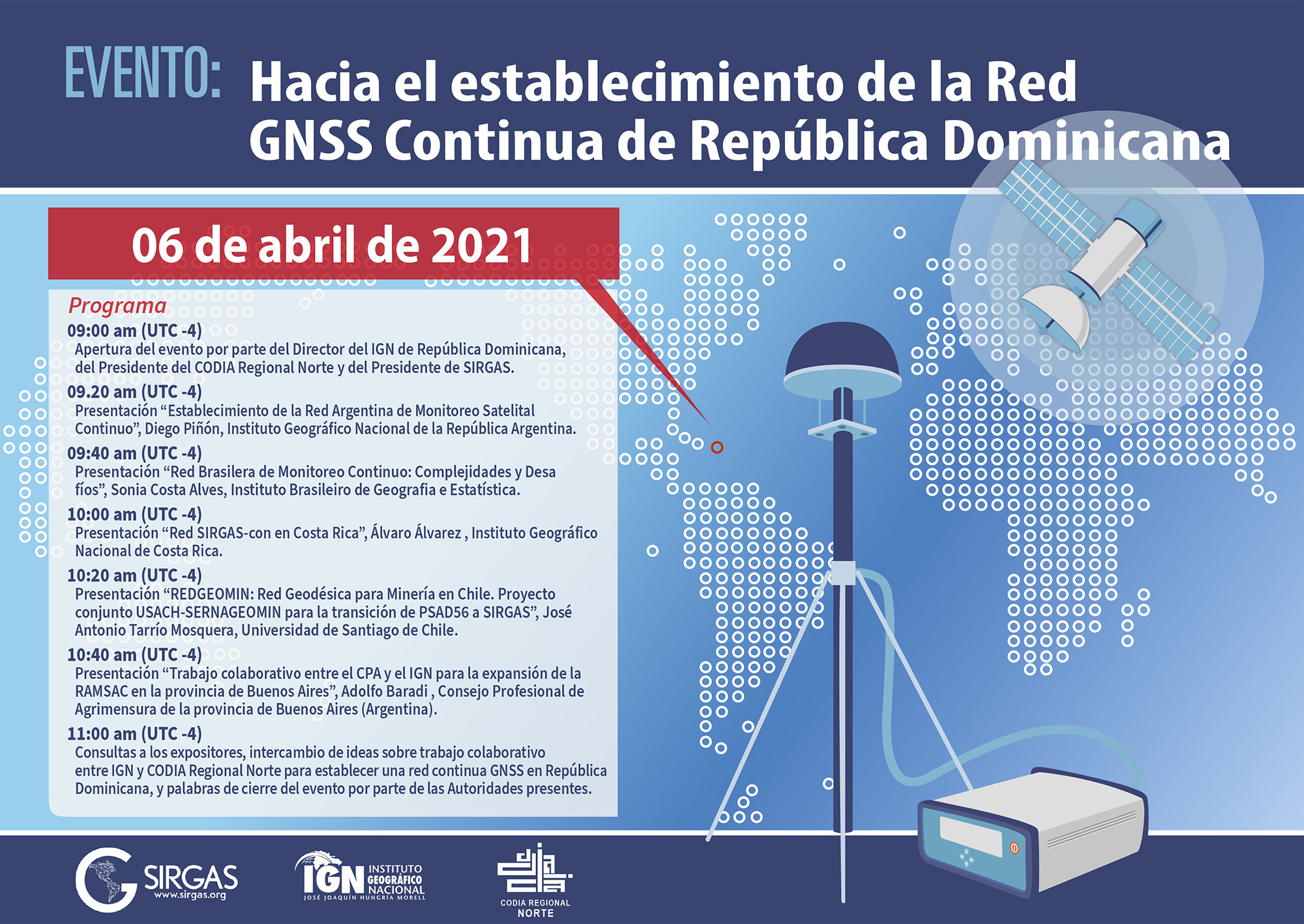
As part of the communication program of the geodetic activities carried out in the Americas and the Caribbean, SIRGAS invites the geodetic community to participate in the webinar “Geodetic activities in the Americas“. The following presentations will be held there:

  • Venezuela, aiming at the reestablishment of the national geodetic system

For some years, Venezuela has gone through political, economic and social situations, which have led to the disappearance of the national geodetic system. Currently, despite going through a difficult time historically, the restructuring of its continuous monitoring system and the proposal of an experimental processing center focused on GNSS data has been proposed.

Speaker: Miguel Ríos (IGVSB)

  • The National Geodetic Network: a continuous and essential service for the planning of territorial development in Colombia

The presentation aims to show how in Colombia the National Geodesic Network, through the Multipurpose Cadastre, has acquired relevant importance in the development processes of Territorial Entities, in particular, those established in Development Projects with a Territorial Approach (PDET), inasmuch as it provides the spatial framework on which all the training, updating and cadastral conservation activities are developed for the preparation and strengthening of the Territorial Development Plans in their environmental, social and economic components.

This approach seeks to strengthen the processes for the standardization and integration of data within the framework of the Spatial Data Infrastructure (ICDE), so as to allow the implementation of strategies that facilitate the sharing of GNSS technological infrastructure to provide free, accurate information, quality, opportunity and covering the largest amount of the national territory. With the strengthening of the National Geodetic Network, it is conceived to implement services in real time that meet the needs of users who require precise coordinates for the development of their projects, through RTCM Network Transport via Internet Protocol (NTRIP), Virtual Reference Stations (VRS) and Processing in a Precise Point Web environment (PPP), through a strengthened Control Center that allows administering and managing active and passive networks, so that through a series of alerts it allows administrators The system should act promptly and clearly inform users of the state of the network at a given moment.

With this modernization project of the National Geodesic Network, through the multipurpose Cadastre, geodesy becomes a continuous and essential service for the planning of Territorial development in Colombia and is consolidated as a support tool for the elaboration of public policies, programs and projects of the national, departmental and municipal governments.

Speaker: José Ricardo Guevara (IGAC)


Event date:

July 29, 2021 03:00 p.m. (UTC)


Meeting link:

https://reuna.zoom.us/j/83301223849?pwd=czUzeXAwOXQvS2JXYnpxRE5Ra0Mwdz09#success
Meeting ID: 833 0122 3849
Access code: 403601

Evento SIRGAS República Dominicana

Event: Towards the establishment of the Continuous GNSS Network of the Dominican Republic

In this event, presentations will be made on the experiences of some countries in the Americas in the establishment and operation of active GNSS networks, more specifically on cooperation between various agencies and the establishment of new strategic alliances for the operation of this type of networks as frameworks. national benchmarks.

Exhibitors: Argentina, Brazil, Costa Rica and Chile
National Geographic Institute of the Argentine Republic – IGN-Ar
Brazilian Institute of Geography and Statistics – IBGE
National Geographic Institute of Costa Rica – IGN
University of Santiago de Chile – USACH
National Geology and Mining Service – SERNAGEOMIN (Chile)
Professional Council of Surveying of the province of Buenos Aires (Argentina)

Date: April 6, 2021, 13:00 UTC
Duration: 2 hours + 15 questions

Meeting link:
https://reuna.zoom.us/j/84147002753?pwd=VWlidnlWZjJ4TjdaeEI0RGRZNDhWQT09
Meeting ID: 841 4700 2753
Access code: 103582

Webinario SIRGAS IGRF

Webinar: The new International Gravity Reference System (IGRS) and its materialization (IGRF)

Abstract:

The increasing importance of terrestrial gravimetry requires a stable reference system that reflects the precision achieved by modern gravimeters. Over the past decade, the International Association for Geodesy (IAG) has developed a system for achieving accurate, homogeneous, long-term global monitoring of the Earth’s gravity field, while harnessing the potential of current absolute gravity measurements. The webinar will be focused on addressing the concepts around the International Gravity Reference System (IGRS) and its materialization, the IGRF, established from Resolutions N ° 2 (2015) and N ° 4 (2019) of the IAG. Subsequently, the regional impact of the establishment of the IGRS / IGRF will be analyzed through the Argentine-German Geodesy Observatory (AGGO) as the IGRF reference station.

Exhibitors:

Hartmut Wziontek

Federal Agency for Cartography and Geodesy (BKG), Germany
President of the IAG Joint Working Group 2.1.1: Establishment of an International Gravity Reference Frame

Ezequiel D. Antokoletz

Faculty of Astronomical and Geophysical Sciences of the National University of La Plata, Argentina
National Council for Scientific and Technical Research (CONICET), Argentina
Federal Agency for Cartography and Geodesy (BKG), Germany
Coordinator “Gravimetric Reference” within the GT-III of SIRGAS

Date: March 5, 2021
Time: 15:00 UTC
Duration: 45 minutes + 15 questions

Meeting link:
https://reuna.zoom.us/j/81278346287?pwd=OCtzY2hTM1RxRnlUOXVZY0grVTB3dz09
Meeting ID: 812 7834 6287
Access code: 197162

Estatuto SIRGAS

New SIRGAS statute and SIRGAS 2020 Resolutions

During the SIRGAS2020 virtual Symposium, the SIRGAS Board of Directors approved an updated and extended version of the SIRGAS statute and generated a series of Resolutions related to the creation of the GRFA Working Group within the UN-GGIM Regional Committee: Americas, the Plan of SIRGAS work for the year 2021, the development of a new Joint Action Plan between the PAIGH, UN-GGIM Americas, SIRGAS and GeoSUR, and the recognition of colleagues and organizations that contribute to SIRGAS.