New SIRGAS stations from Costa Rica
In November 2022, new stations in Costa Rica were included in the SIRGAS Network. They are:
- CAPO00CRI (Cariari de Pococí),
- LBRA00CRI (Liberia),
- PJMZ00CRI (Puerto Jiménez).
Loading


In November 2022, new stations in Costa Rica were included in the SIRGAS Network. They are:
From November 2th to 4th was held the Vertical Reference System Workshop exploring topics related to the unification of the vertical datum for the SIRGAS country members, according to the guidelines and actions directed towards the materialization of the IHRS (International Height Reference System). The workshop main objective was to contribute to the training process of researchers, professionals, and technicians of the Americas who participate in the investigation, definition, and updating of national vertical reference frames and systems based on the processing of gravimetric and classical leveling information. The attendees were trained in the use of program packages developed by the International Association of Geodesy (IAG) and SIRGAS, which are freely distributed for those organizations dedicated for the materialization of national geodetic reference frames, or that contribute to the activities and research carried out by SIRGAS.
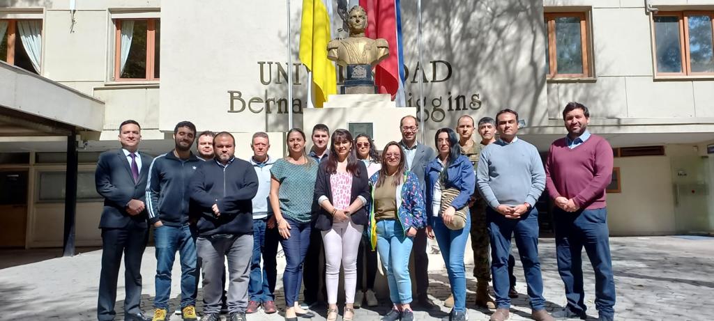
This workshop was coordinated jointly with the Military Geographic Institute of Chile at the facilities of the Bernardo O’Higgins University and was given in Spanish by Dr. Gabriel do Nascimento Guimarães (Federal University of Uberlândia) and Hernán Javier Guagni from the Institute National Geographic of Argentina. The workshop participation accomplished Fourteen professionals from 7 countries of the American continent.
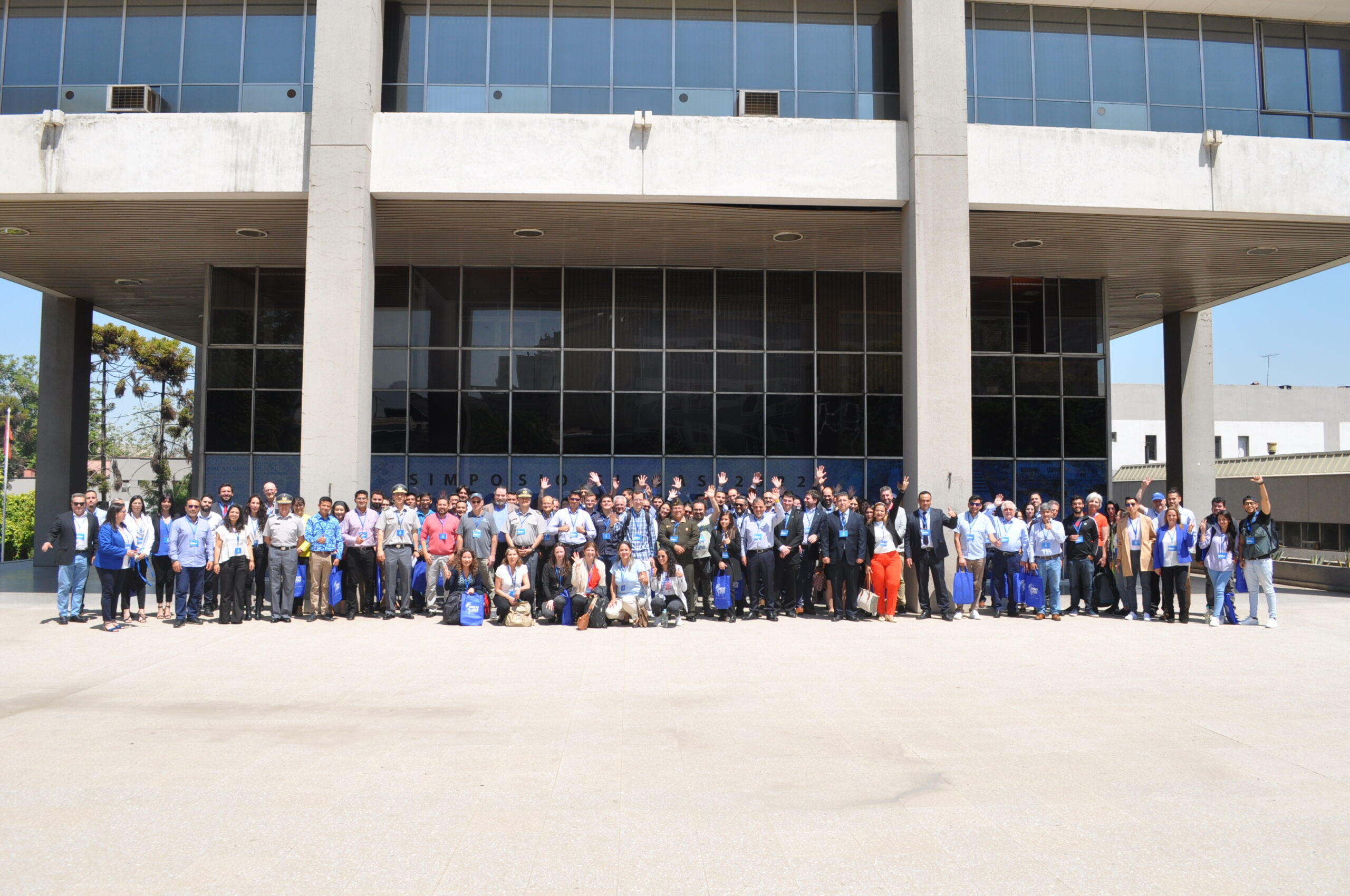
From November 7th to 9th, was held the SIRGAS 2022 Symposium in Santiago, Chile, under the organization of the Military Geographic Institute (IGM) of Chile. The central purpose of the SIRGAS 2022 Symposium was to call the geodetic community of the Americas and Caribe dedicated to the study of problems related to Earth observation and global changes. Including the establishment of reference systems, the Earth’s gravity field and rotation monitoring, as well, the deformation of the Earth’s crust, including oceans and ice, and geodetic positioning for interdisciplinary use. The combination of several technologies, among which GNSS stands out, collaborate in the modeling improvement of seismological and atmospheric processes, contributing to the mitigation of natural disasters caused by seismic activity, to the weather forecast and to the sea level rise monitoring. It was the first time that the Symposium was held in a hybrid way (face-to-face and online) and the second time with simultaneous translation, important changes to promote the participation of more countries on the continent.
There were 59 presentations from the following countries: Germany, Argentina, Canada, the United States, Costa Rica, Colombia, Brazil, Ecuador, Bolivia, Chile and Uruguay. The average number of attendees during the 3 days was 90 participants in person and 130 remotely. SIRGAS activities were carried out since 1993 in the American continent and are aligned to support the Nations of the Americas in response to the United Nations General Assembly Resolution entitled “A Global Geodetic Reference Frame for Sustainable Development” (A/RES/69/266), through the modernization and unification of the Geodetic Reference System of the Americas. The unification and integration are important for the development of infrastructure, such as: roads, sanitation, energy, and land reform, as well as for climate change monitoring and preventing natural disasters. To align SIRGAS activities to the GGRF (Global Geodetic Reference Frame) Roadmap, a resolution dealing with the opening of GNSS data repositories was approved last year by the Directing Council. This year, the proposed resolution submitted for approval deals with the advances to the implementation of Resolution 69/266. One of the objectives is to support and encourage the development of geodetic capabilities within the Americas and the Caribbean for the establishment and maintenance of a high-precision geocentric network, as an ITRF, IHRF, and ITGRF densification in the continent and the link of national geodetic infrastructures in the region, as well as, the connection of the national reference frames towards the ITRF, IHRF and ITGRF.
The next symposium will be in 2024 in Bogotá, Colombia, coordinated by the Agustin Codazzi Geographic Institute (IGAC).
From November 2th to 4th was held the Vertical Reference System Workshop exploring topics related to the unification of the vertical datum for the SIRGAS country members, according to the guidelines and actions directed towards the materialization of the IHRS (International Height Reference System).
The workshop main objective was to contribute to the training process of researchers, professionals, and technicians of the Americas who participate in the investigation, definition, and updating of national vertical reference frames and systems based on the processing of gravimetric and classical leveling information. The attendees were trained in the use of program packages developed by the International Association of Geodesy (IAG) and SIRGAS, which are freely distributed for those organizations dedicated for the materialization of national geodetic reference frames, or that contribute to the activities and research carried out by SIRGAS.
This workshop was coordinated jointly with the Military Geographic Institute of Chile at the facilities of the Bernardo O’Higgins University and was given in Spanish by Dr. Gabriel do Nascimento Guimarães (Federal University of Uberlândia) and Hernán Javier Guagni from the Institute National Geographic of Argentina. The workshop participation accomplished Fourteen professionals from 7 countries of the American continent.
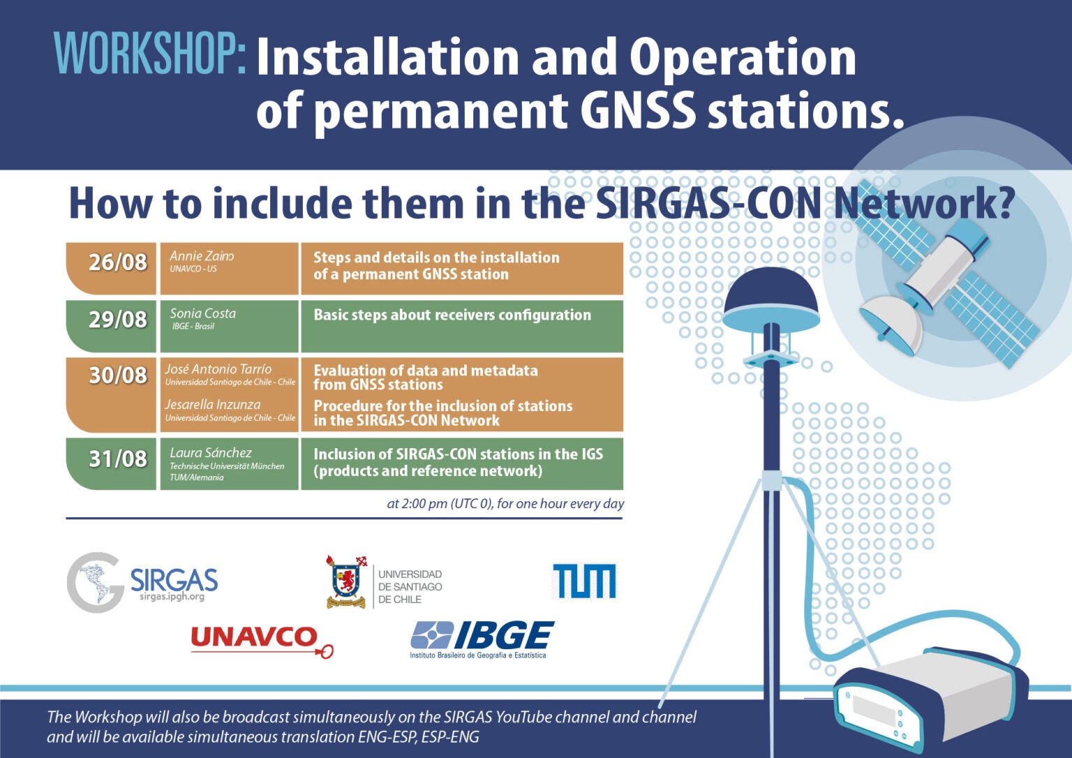
Between August 26 and 31, 2022, the virtual workshop “Installation and operation of permanent GNSS stations will be held. How to include them in SIRGAS-CON?” This workshop is aimed at the geodetic community of SIRGAS and the Caribbean, mainly at current and future GNSS data centers and the main objective is to train participants on the installation and operation of permanent GNSS stations, carrying out a series of practical activities. about the metadata, formats and contribution of SIRGAS to the products and IGS reference framework.
This workshop will be held through the Zoom platform, on August 26, 29, 30 and 31, 2022, at 2:00 p.m. (UTC 0), lasting one hour every day.
The Workshop will also be broadcast simultaneously on the SIRGAS YouTube channel, and will have simultaneous translation ENG-ESP, ESP-ENG
Registration: https://reuna.zoom.us/meeting/register/tZwude6hrTgtHtRznzK5F7g_z8CJkp0gO5YD
Programming:
Day |
Exhibitor |
Subject |
26/08 |
Annie Zaino
UNAVCO – US |
Steps and details on the installation of a permanent GNSS station |
29/08 |
Sonia Costa
IBGE – Brasil |
Basic steps about receivers configuration |
30/08 |
José Antonio Tarrío
Universidad Santiago de Chile – Chile Jesarella Inzunza Universidad Santiago de Chile – Chile |
Evaluation of data and metadata from GNSS stations
Procedure for the inclusion of stations in the SIRGAS-CON Network |
31/08 |
Laura Sanchez
Technische Universität München – TUM/Alemania |
Inclusion of SIRGAS-CON stations in the IGS (products and reference network) |
The next SIRGAS Symposium will be held in the city of Santiago de Chile, November 7-9, 2022, thanks to the invitation offered by the Instituto Geográfico Militar (IGM) of Chile, in celebration of its 100th anniversary. The geodetic community of the Americas and the Caribbean will gather during this event to formulate new projects and exchange experiences and progress related to the implementation, maintenance and use of the geodetic reference frame and infrastructure of the region.
In addition, the Vertical Reference System Workshop will take place the week before the Symposium, November 2-4 2022, which will cover topics related to the unification of the vertical reference in the SIRGAS member states, as well as the guidelines and actions planned for the materialization of the IHRS (International Height Reference System).
This edition of the SIRGAS Symposium and the Vertical Reference System Workshop is jointly organized with the Military Geographic Institute of Chile, and has the support of the Pan-American Institute of Geography and History (PAIGH) and the International Association of Geodesy (IAG).
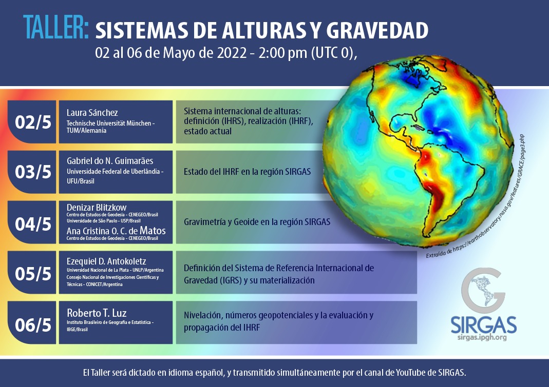
Objective: This Workshop is aimed at the SIRGAS community, and the objective is to create capacity on height systems (IHRS/IHRF), gravity systems (IGRS/IGRF), and to update the practical activities about heights, gravity, and geoid in SIRGAS.
Format: This Workshop will be held through the Zoom platform, between May 2 to 6, 2022, at 2:00 PM (UTC 0), for one hour every day. The Workshop will be in Spanish.
The Workshop will also be broadcast simultaneously on the SIRGAS YouTube channel.
Application form: https://forms.gle/WnKzknFt8G9cqRAZ7
Program:
Day |
Exhibitor |
Topic |
02/05 |
Laura Sánchez
Technische Universität München – TUM/Germany |
International Height System: Definition (IHRS), Realization (IHRF), Current Status |
03/05 |
Gabriel do N. Guimarães
Universidade Federal de Uberlândia – UFU/Brazil |
Status of the IHRF in the SIRGAS region |
04/05 |
Denizar Blitzkow
Centro de Estudos de Geodesia – CENEGEO/Brazil Universidade de São Paulo – USP/Brasil Ana Cristina O. C. de Matos Centro de Estudos de Geodesia – CENEGEO/Brazil |
Gravimetry and Geoid in the SIRGAS region |
05/05 |
Ezequiel D. Antokoletz
Universidad Nacional de La Plata – UNLP/Argentina |
Definition of the International Gravity Reference System (IGRS) and its materialization |
06/05 |
Roberto T. Luz
Instituto Brasileiro de Geografia e Estatística – IBGE/Brazil |
Leveling, geopotential numbers and the evaluation and propagation of the IHRF |
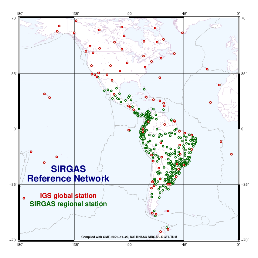
Within the framework of the SIRGAS mission (defined in Art.1 of the statute approved by the SIRGAS Board of Directors on November 19, 2020), and in accordance with the resolution “A Global Geodetic Reference Frame for Sustainable Development” (A /RES/69/266) adopted by the United Nations General Assembly in 2015, which recognizes the economic and scientific importance and the growing need to have an accurate and stable global geodetic reference frame for the Earth, the following continuously operating stations in Argentina, Colombia and Costa Rica have been incorporated into the SIRGAS-CON network:
AEPL00COL (Planadas), ALTA00ARG (Los Altares), BRBR00CRI (Bribrí), CANO00COL (Puerto Carreño), CHLS00CRI (Los Chiles), LCRZ00CRI (La Cruz), LROS00ARG (Las Rosas), MBIO00ATA (Marambio Base), OBRA00ARG (Obera) , PDE300ARG (Puerto Deseado), PELU00ARG (Pedro Luro), QUEP00CRI (Quepos), SICO00ARG (Sierra Colorada), SMDM00ARG (San Miguel del Monte), SPRZ00ATA (Base Esperanza), TGTA00ARG (Tinogasta), TOSF00ARG (Tostado).
The contributions made by Argentina, Colombia and Costa Rica are an active contribution to the definition of regional and international geodetic reference frames in the Americas.
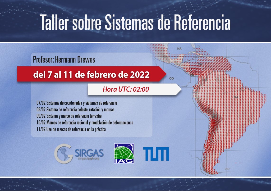
Professor: Hermann Drewes
Objective: This workshop is aimed at the SIRGAS community and the objective is to create capacity on Reference systems, deformation modeling and use of reference frames in practice.
Format: With the support and collaboration of the International Association of Geodesy, this Workshop will be held through the Zoom platform, between February 7 to 11, 2022, at 2:00 PM UTC, for one hour. every day. The Workshop will be in Spanish.
The Workshop will also be streamed simultaneously on the SIRGAS YouTube channel, every day from February 7th to 11th at 02:00 PM (0 UTC)