SIRGAS

Loading

SIRGAS

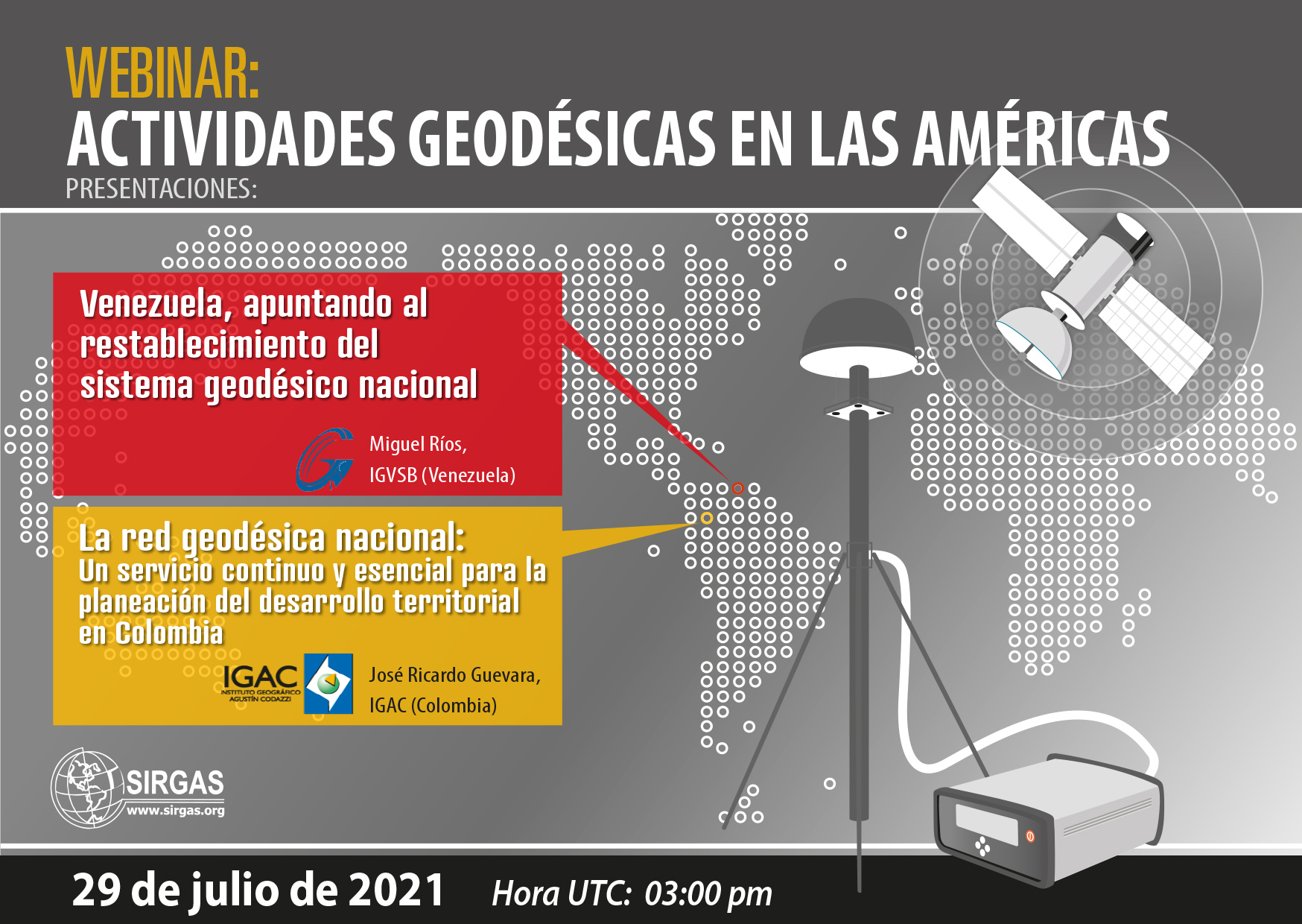
New SIRGAS web site: https://sirgas.ipgh.org/

In October 2002, the SIRGAS Directing Council decided the implementation of a web page summarising the main characteristics of SIRGAS. The design, maintenance and update of the SIRGAS web page was defined as a responsibility of the SIRGAS President and Vice-president. The first version of the SIRGAS web page was hosted by the Instituto Brasileiro de Geografia e Estatística (IBGE), affiliation of the SIRGAS President at that time, Luiz Paulo Souto Fortes. This web site described the objectives and structure of SIRGAS, included the new SIRGAS Bylaws, and contained the main SIRGAS products: SIRGAS95 and SIRGAS2000 coordinates and the first VEMOS model. Through this web site the routinely issue of the SIRGAS Newsletters was established. In December 2004, the SIRGAS Vice-president for the term 2003 – 2007, Eduardo Lauría, assumed the maintenance and modernisation of the SIRGAS web site and moved the wen from IBGE to the Instituto Geográfico Nacional (IGN) of Argentina. This new site offered interactive tools to easily find the SIRGAS95 and SIRGAS2000 coordinates for desired stations as well as to get station velocities from the VEMOS model. New sections corresponding to the SIRGAS Working Groups were introduced. In August 2007, the responsibility of the SIRGAS web maintenance is assumed by the new SIRGAS Vice-president, Laura Sánchez (term 2007 – 2015), and with the support of the Deutsches Geodätisches Forschungsinstitut, Technische Universität München (DGFI-TUM), the web is moved to www.sirgas.org. This new site initially kept the same design introduced by the IGN-Argentina and IBGE in the previous web sites, but the structure of the web is modified in accordance with the development of SIRGAS. New sections are implemented following the establishment of new SIRGAS components, in particular, the continuously operating reference network, the SIRGAS analysis centres of the reference network, the atmospheric analysis centres, and the SIRGAS products (weekly station positions, multi-year solution, deformation models VEMOS). An important component of the www.sirgas.org is the repository of a huge index of publications and presentations published by the SIRGAS community. In accordance with the recent developments in SIRGAS, specially the interaction with the Regional Committee of the United Nations on Global Geospatial Information Management for the Americas (UN-GGIM: Americas), it was decided to move the SIRGAS web page from www.sirgas.org to https://sirgas.ipgh.org/. The new site is hosted by the Pan-American Institute for Geography and History (PAIGH). Its maintenance continues being a responsibility of the SIRGAS President and Vice-president with the support of PAIGH. https://sirgas.ipgh.org/ contains basically the same information and data like www.sirgas.org, so that the SIRGAS users can assumed this transition smoothly. https://sirgas.ipgh.org/ is operative since August 2021.

Event: Geodetic Activities in the Americas

As part of the communication program of the geodetic activities carried out in the Americas and the Caribbean, SIRGAS invites the geodetic community to participate in the webinar “Geodetic activities in the Americas“. The following presentations will be held there:

  • Venezuela, aiming at the reestablishment of the national geodetic system

For some years, Venezuela has gone through political, economic and social situations, which have led to the disappearance of the national geodetic system. Currently, despite going through a difficult time historically, the restructuring of its continuous monitoring system and the proposal of an experimental processing center focused on GNSS data has been proposed.

Speaker: Miguel Ríos (IGVSB)

  • The National Geodetic Network: a continuous and essential service for the planning of territorial development in Colombia

The presentation aims to show how in Colombia the National Geodesic Network, through the Multipurpose Cadastre, has acquired relevant importance in the development processes of Territorial Entities, in particular, those established in Development Projects with a Territorial Approach (PDET), inasmuch as it provides the spatial framework on which all the training, updating and cadastral conservation activities are developed for the preparation and strengthening of the Territorial Development Plans in their environmental, social and economic components.

This approach seeks to strengthen the processes for the standardization and integration of data within the framework of the Spatial Data Infrastructure (ICDE), so as to allow the implementation of strategies that facilitate the sharing of GNSS technological infrastructure to provide free, accurate information, quality, opportunity and covering the largest amount of the national territory. With the strengthening of the National Geodetic Network, it is conceived to implement services in real time that meet the needs of users who require precise coordinates for the development of their projects, through RTCM Network Transport via Internet Protocol (NTRIP), Virtual Reference Stations (VRS) and Processing in a Precise Point Web environment (PPP), through a strengthened Control Center that allows administering and managing active and passive networks, so that through a series of alerts it allows administrators The system should act promptly and clearly inform users of the state of the network at a given moment.

With this modernization project of the National Geodesic Network, through the multipurpose Cadastre, geodesy becomes a continuous and essential service for the planning of Territorial development in Colombia and is consolidated as a support tool for the elaboration of public policies, programs and projects of the national, departmental and municipal governments.

Speaker: José Ricardo Guevara (IGAC)


Event date:

July 29, 2021 03:00 p.m. (UTC)


Meeting link:

https://reuna.zoom.us/j/83301223849?pwd=czUzeXAwOXQvS2JXYnpxRE5Ra0Mwdz09#success
Meeting ID: 833 0122 3849
Access code: 403601

Evento SIRGAS República Dominicana

Event: Towards the establishment of the Continuous GNSS Network of the Dominican Republic

In this event, presentations will be made on the experiences of some countries in the Americas in the establishment and operation of active GNSS networks, more specifically on cooperation between various agencies and the establishment of new strategic alliances for the operation of this type of networks as frameworks. national benchmarks.

Exhibitors: Argentina, Brazil, Costa Rica and Chile
National Geographic Institute of the Argentine Republic – IGN-Ar
Brazilian Institute of Geography and Statistics – IBGE
National Geographic Institute of Costa Rica – IGN
University of Santiago de Chile – USACH
National Geology and Mining Service – SERNAGEOMIN (Chile)
Professional Council of Surveying of the province of Buenos Aires (Argentina)

Date: April 6, 2021, 13:00 UTC
Duration: 2 hours + 15 questions

Meeting link:
https://reuna.zoom.us/j/84147002753?pwd=VWlidnlWZjJ4TjdaeEI0RGRZNDhWQT09
Meeting ID: 841 4700 2753
Access code: 103582

Webinario SIRGAS IGRF

Webinar: The new International Gravity Reference System (IGRS) and its materialization (IGRF)

Abstract:

The increasing importance of terrestrial gravimetry requires a stable reference system that reflects the precision achieved by modern gravimeters. Over the past decade, the International Association for Geodesy (IAG) has developed a system for achieving accurate, homogeneous, long-term global monitoring of the Earth’s gravity field, while harnessing the potential of current absolute gravity measurements. The webinar will be focused on addressing the concepts around the International Gravity Reference System (IGRS) and its materialization, the IGRF, established from Resolutions N ° 2 (2015) and N ° 4 (2019) of the IAG. Subsequently, the regional impact of the establishment of the IGRS / IGRF will be analyzed through the Argentine-German Geodesy Observatory (AGGO) as the IGRF reference station.

Exhibitors:

Hartmut Wziontek

Federal Agency for Cartography and Geodesy (BKG), Germany
President of the IAG Joint Working Group 2.1.1: Establishment of an International Gravity Reference Frame

Ezequiel D. Antokoletz

Faculty of Astronomical and Geophysical Sciences of the National University of La Plata, Argentina
National Council for Scientific and Technical Research (CONICET), Argentina
Federal Agency for Cartography and Geodesy (BKG), Germany
Coordinator “Gravimetric Reference” within the GT-III of SIRGAS

Date: March 5, 2021
Time: 15:00 UTC
Duration: 45 minutes + 15 questions

Meeting link:
https://reuna.zoom.us/j/81278346287?pwd=OCtzY2hTM1RxRnlUOXVZY0grVTB3dz09
Meeting ID: 812 7834 6287
Access code: 197162

Estatuto SIRGAS

New SIRGAS statute and SIRGAS 2020 Resolutions

During the SIRGAS2020 virtual Symposium, the SIRGAS Board of Directors approved an updated and extended version of the SIRGAS statute and generated a series of Resolutions related to the creation of the GRFA Working Group within the UN-GGIM Regional Committee: Americas, the Plan of SIRGAS work for the year 2021, the development of a new Joint Action Plan between the PAIGH, UN-GGIM Americas, SIRGAS and GeoSUR, and the recognition of colleagues and organizations that contribute to SIRGAS.

Logo IGN Peru

New Experimental Processing Center SIRGAS in Peru

The National Geographic Institute of Peru (IGN-Pe) begins activities as an Experimental Processing Center SIRGAS from GPS week 2120 (August 23, 2020). The main characteristics of this new Experimental Center are:

Name: National Geographic Institute of Peru
Abbreviation: PER
Processed stations: AACR ABMF ABPW AM04 AMTE AN02 ANDS AP01 AQ01 ARCA AREQ AY02 BECE BEJA BNGA BOGT BRMU CHEP CHET CIQE CJ01 CN19 CN30 COL2 CRLP CRO1 CS01 CULC DARI FQNE GLPS GODE AREQ AY02 ICGO JU01 GUA ID LEG01 GOL2 GOLD01 GRE1 GUA ID GODAZ GOL2 GOLD01 GRE1 GUA IP GODAZ GOL2 GOLD01 HIC01 GUA IP GODAZ GOL2 GOLD IN1 GUA IP JU01 LEG01 H LIMN LR01 MANA MD01 MDO1 MEDE MERI MEXI MTY2 NAS0 NEIL OAX2 PASM PI01 PIE1 PU02 RDSD RIDC SAGE SCUB SM01 STJO TAMP TC01 TEG2 TOL2 UC01 UCRI UGTO USNO VIL2 VNDP ZARZ
Software: GAMIT GLOBK 10.71

With this new experimental processing center, SIRGAS is approaching the goal of having a scientific GNSS data processing center in each country in the region. SIRGAS thanks IGN-Pe for this initiative and for its continued support in all activities related to the establishment, maintenance, and development of the reference framework for the Americas.