SIRGAS

Loading

SIRGAS

Advanced Space Geodesy Data Processing with BSW 5.4: GNSS Techniques and Nonlinear Models

The SIRGAS course “Advanced Spatial Geodesy Data Processing with BSW 5.4: GNSS Techniques and Nonlinear Models” will be held from July 14 to 18, 2025.

It will take place at the University of Costa Rica, in San José, Costa Rica. The course will be in person and taught exclusively in Spanish.

A five-day course for advanced professionals, young scientists and national agency staff, covering the fundamental topics of SIRGAS campaign processing with BSW 5.4 and nonlinear models, kinematic reference frames.

Registration Here

Deadline for registration: June 15, 2025.

Location:

School of Topographic Engineering, Faculty of Engineering, University of Costa Rica,

https://maps.app.goo.gl/JHryb9oJZrsZDVUw6 

New scientific publication

We are pleased to share the recent publication by Mariana Inoue and Gabriel Guimarães (2025), entitled:
“Development and Evolution of Height Systems in the Context of SIRGAS: From Local Vertical Data to the International Height Reference Framework,” in the Journal of Geodetic Science.

Este artigo aborda a transição dos sistemas de referência verticais locais para a integração com a estrutura internacional fornecida pelo SIRGAS, destacando avanços metodológicos, desafios técnicos e a importância da unificação regional para aplicações geodésicas de alta precisão.

IGAC presents results of potential calculations for the IHRF MEDE station

Personnel from the Agustín Codazzi Geographic Institute (IGAC) presented the results of calculations of potential values ​​for the IHRF MEDE station, located in Medellín.

This information was expressed during a meeting with the president of the Working Group III (GT-III) – Gabriel do Nascimento Guimarães, as part of regional efforts aimed at establishing a unified vertical reference framework for the American continent.

Furthermore, the IGAC staff shared the preliminary results of a geoid model developed for the region of the MEDE station, which constitutes a significant advance in improving the geodesic and altimetric precision of the country and the region.

These works reflect IGAC’s commitment to international geodesic integration and strengthening of spatial data infrastructure in Colombia.

SIRGAS Working Group 1 (WG1) Meeting: Change of Network Coordinator

An important coordination meeting of SIRGAS Working Group 1 (WG1) was held on May 12th, where the changeover in Network Coordination was formalized. During the meeting, Alberto Luis Da Silva, the outgoing coordinator, presented a detailed technical report on the activities carried out during his tenure. From SIRGAS, we express our sincere gratitude for his dedication, commitment, and valuable contribution to strengthening our geodetic infrastructure. We wish him every success in his future endeavors. In her place, Claudia Cristina Cunha Santos da Silva, nominated by the Brazilian Institute of Geography and Statistics (IBGE), was introduced as the new coordinator. We warmly welcome Claudia, confident that her experience and leadership will be key to continuing to advance the objectives of WG1 and the development of regional geodetic networks. We extend special thanks to IBGE, represented by Maira Kronemberg, Brazil’s national delegate to SIRGAS, as well as to the entire Geodesy team at the Institute, for their ongoing support and commitment to the program.

Jamaica joins the Geodetic Reference System for the Americas (SIRGAS)

We are pleased to announce the incorporation of Jamaica as a new member of the Geodetic Reference System for the Americas (SIRGAS). This important addition represents a significant step toward strengthening technical and scientific cooperation among Latin American and Caribbean countries in the field of geodesy.

Jamaica’s participation will substantially contribute to improving the accuracy and consistency of the geodetic reference frames used throughout the region, thus promoting a more robust and reliable geospatial infrastructure.

At SIRGAS, we celebrate this integration and extend a warm welcome to Jamaica, firmly convinced that working together will contribute to capacity building, knowledge sharing, and the consolidation of a robust geodetic infrastructure on our continent.

Welcome, Jamaica, to the SIRGAS family!

XVI SIRGAS School “VLBI and SLR Data Processing”

The XVI SIRGAS School will be held in the beautiful city of San Juan, Argentina, with the aim of training professionals in the field of geodesy through the processing of VLBI (Very Long Baseline Interferometry) and SLR (Satellite Laser Ranging) data, key techniques for the definition of global reference frames.

🗓️ Dates: From Monday, October 27 to Saturday, November 1, 2025

📍 Location: San Juan, Argentina.

🎯 Course Objective:

The purpose of this course is to provide the theoretical concepts and practical tools necessary for the analysis and processing of VLBI and SLR techniques, delving into their application in the definition and maintenance of geodetic reference frames.

👥Addressed to:

    • Graduates in geodesy and related fields
    • Scientists specializing in geodesy
    • Employees of national mapping agencies
    • Students interested in geodesy and space technology

Allocation of Places for the XVI SIRGAS School

The SIRGAS Executive Committee will have 10 special spots, which will be assigned among the 50 participants selected to attend the UN-GGCE Workshop.

These positions will be assigned based on academic profile, professional experience, and commitment to strengthening geodesy in the region.

👉 Registration Form – XVI SIRGAS School

Registration deadline for the XVI SIRGAS School: Friday, May 9, 2025

📌 Registration:

Those interested must complete the Registration Form to confirm their participation. Registration is also required for the UN-GGCE Workshop: Capacity Building in Geodesy, in Santiago, Chile.

👉Registration – UN-GGCE Workshop

UN-GGCE Workshop registration deadline: Tuesday, April 29, 2025

Virtual School: “Terrestrial Reference Frame. Geodynamic and Atmospheric Monitoring 2025”

Maximum number of applicants!

Date: June 3, 5, 6, 10, and 12, 2025.

UTC time -03:00

  • Tuesday, June 3, 2025 – 9:00 AM to 13:00 AM
  • Thursday, June 5, 2025 – 9:00 AM to 12:50 PM
  • Friday, June 6, 2025 – 9:00 AM to 12:50 PM
  • Tuesday, June 10, 2025 – 9:00 AM to 1:00 PM
  • Thursday, June 12, 2025 – 9:00 AM to 12:55 PM

Location: Virtual; once 500 places are filled, the course will be broadcast on YouTube.

Broadcast: English and Spanish

Course Objective: The objective of the 2025 School is to provide the most important concepts on the definition, implementation, and maintenance of global, continental, and national reference frameworks, as well as their importance in various applications. It will also address advances in Earth System monitoring in response to the challenges posed by climate change, which is already affecting us and impacting our most vulnerable societies.


Geodesy Capacity Development Workshop, in Santiago, Chile.

The United Nations Global Geodetic Centre of Excellence (UN-GGCE) invites surveying and geodetic professionals working for, or with, Member State government agencies in the Americas region to participate in its Geodesy Capacity Development Workshop, in Santiago, Chile. This workshop will assist participants understand how to collaborate with colleagues in government to transition to a modern Geospatial Reference System (GRS).

The attached Concept Note provides more information on the workshop objectives, provisional agenda, target audience and the application process.

Link: Concept Note

Please note, this workshop is focused on surveying and geodetic professionals working for, or with, Member State government agencies in the Americas region. Workshop for the Arab States region is currently in development and will take place later in 2025. We will provide more information on this workshop in the coming months.

Evento SIRGAS República Dominicana

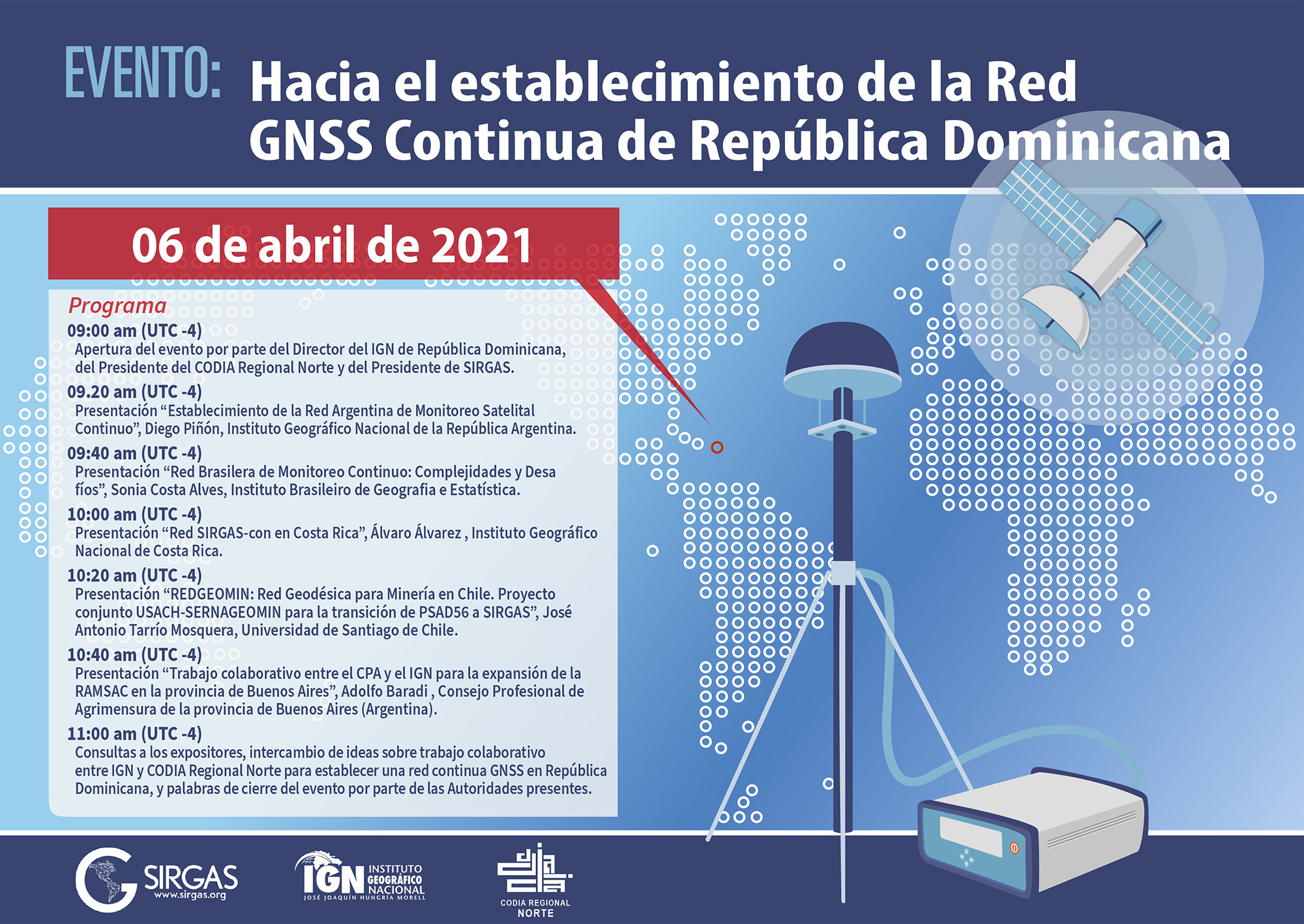
Event: Towards the establishment of the Continuous GNSS Network of the Dominican Republic

In this event, presentations will be made on the experiences of some countries in the Americas in the establishment and operation of active GNSS networks, more specifically on cooperation between various agencies and the establishment of new strategic alliances for the operation of this type of networks as frameworks. national benchmarks.

Exhibitors: Argentina, Brazil, Costa Rica and Chile
National Geographic Institute of the Argentine Republic – IGN-Ar
Brazilian Institute of Geography and Statistics – IBGE
National Geographic Institute of Costa Rica – IGN
University of Santiago de Chile – USACH
National Geology and Mining Service – SERNAGEOMIN (Chile)
Professional Council of Surveying of the province of Buenos Aires (Argentina)

Date: April 6, 2021, 13:00 UTC
Duration: 2 hours + 15 questions

Meeting link:
https://reuna.zoom.us/j/84147002753?pwd=VWlidnlWZjJ4TjdaeEI0RGRZNDhWQT09
Meeting ID: 841 4700 2753
Access code: 103582

Webinario SIRGAS IGRF

Webinar: The new International Gravity Reference System (IGRS) and its materialization (IGRF)

Abstract:

The increasing importance of terrestrial gravimetry requires a stable reference system that reflects the precision achieved by modern gravimeters. Over the past decade, the International Association for Geodesy (IAG) has developed a system for achieving accurate, homogeneous, long-term global monitoring of the Earth’s gravity field, while harnessing the potential of current absolute gravity measurements. The webinar will be focused on addressing the concepts around the International Gravity Reference System (IGRS) and its materialization, the IGRF, established from Resolutions N ° 2 (2015) and N ° 4 (2019) of the IAG. Subsequently, the regional impact of the establishment of the IGRS / IGRF will be analyzed through the Argentine-German Geodesy Observatory (AGGO) as the IGRF reference station.

Exhibitors:

Hartmut Wziontek

Federal Agency for Cartography and Geodesy (BKG), Germany
President of the IAG Joint Working Group 2.1.1: Establishment of an International Gravity Reference Frame

Ezequiel D. Antokoletz

Faculty of Astronomical and Geophysical Sciences of the National University of La Plata, Argentina
National Council for Scientific and Technical Research (CONICET), Argentina
Federal Agency for Cartography and Geodesy (BKG), Germany
Coordinator “Gravimetric Reference” within the GT-III of SIRGAS

Date: March 5, 2021
Time: 15:00 UTC
Duration: 45 minutes + 15 questions

Meeting link:
https://reuna.zoom.us/j/81278346287?pwd=OCtzY2hTM1RxRnlUOXVZY0grVTB3dz09
Meeting ID: 812 7834 6287
Access code: 197162